


Stages
Thurs, 17 September 2026
STAGE - 2
Differdange/Niederkorn → Junglinster
166,8 kms
View moreWinner Stage 2 – Marijn van den Berg
Possibility of a Bunch Sprint
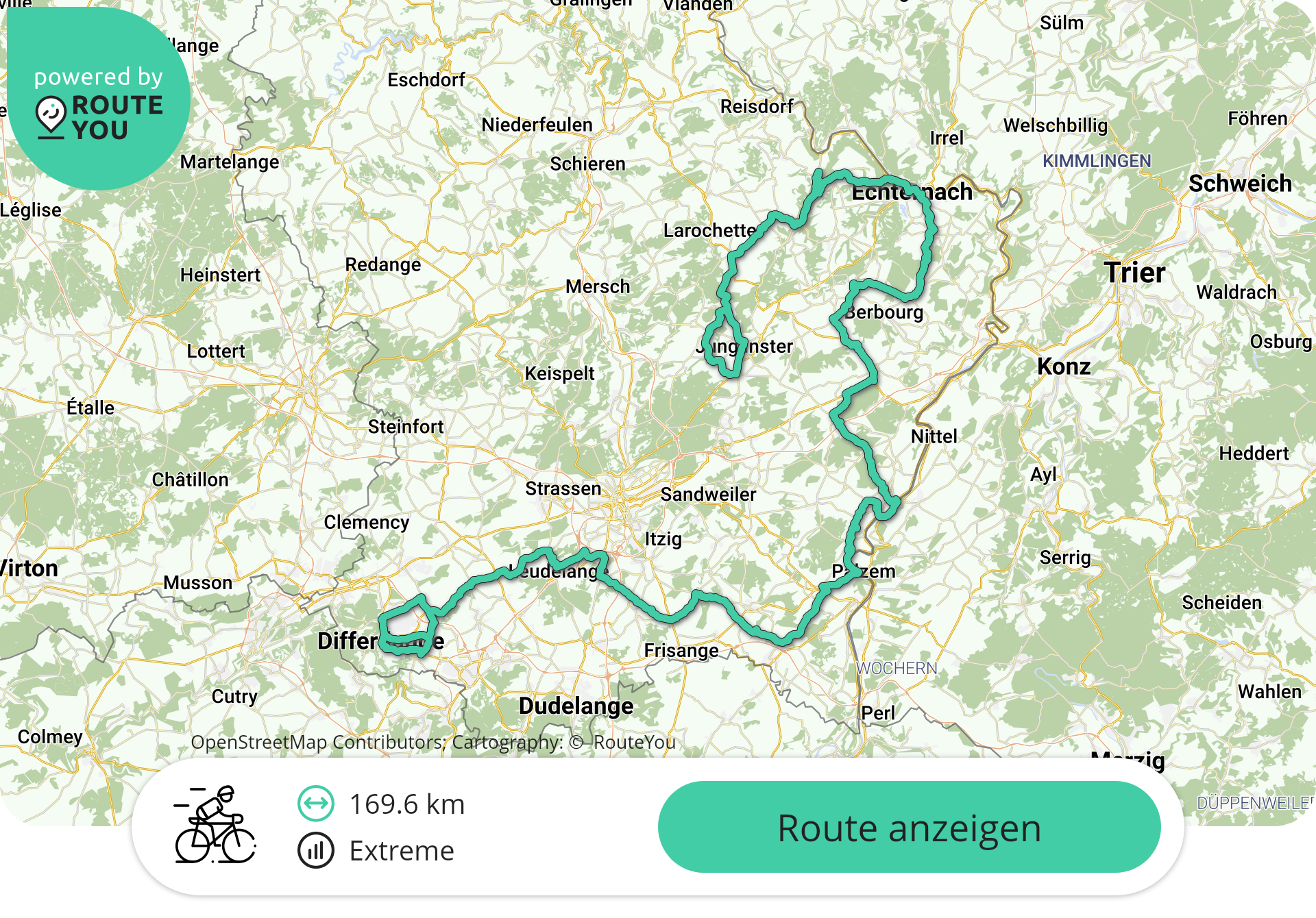
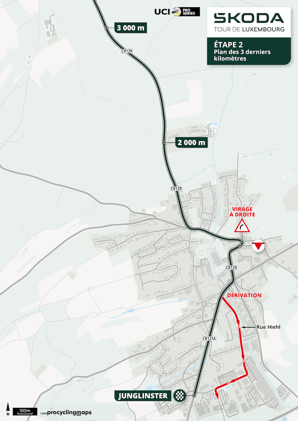
Starting in Differdange/Niederkorn, the peloton heads towards the legendary Mousel climb before continuing through the beautiful Müllerthal region and the historic town of Echternach. The riders then make their way to Junglinster, where they will tackle the finishing circuit.
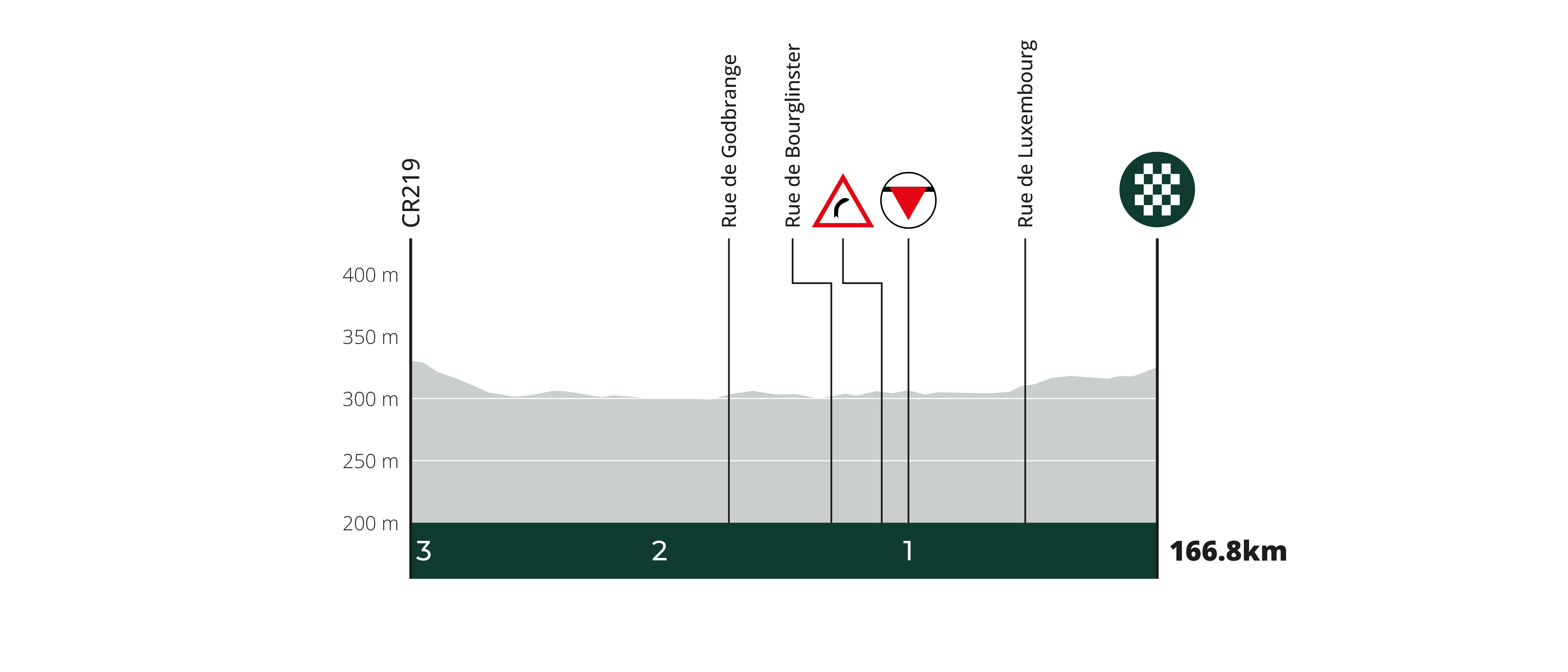
With a relatively favourable profile compared to the other road stages, Stage 2 is expected to suit the sprinters and could provide the fastest finish of the week—provided they can keep the attackers under control.
Stage 2 Highlights:
Stage 2 General Info
| Date | Thursday 17/09 |
|---|---|
| Distance | 166.8 km (+2.7 km) |
| Elevation Gain | 2,326 m (+26 m) |
| Start | Niederkorn (Differdange)
(Avenue de la Liberté, Niederkorn) |
| Team Presentation | 13:20 - 14:20 |
| Finish | Junglinster
(Route de Luxembourg, Junglinster) |
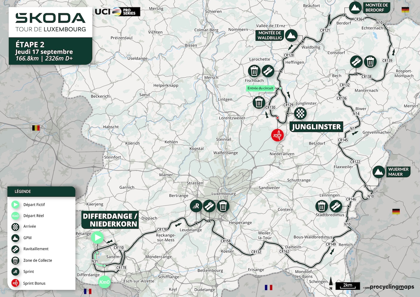
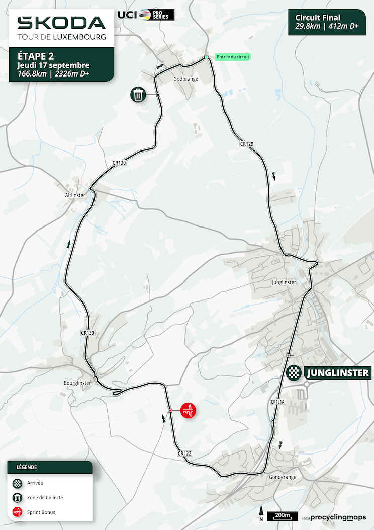
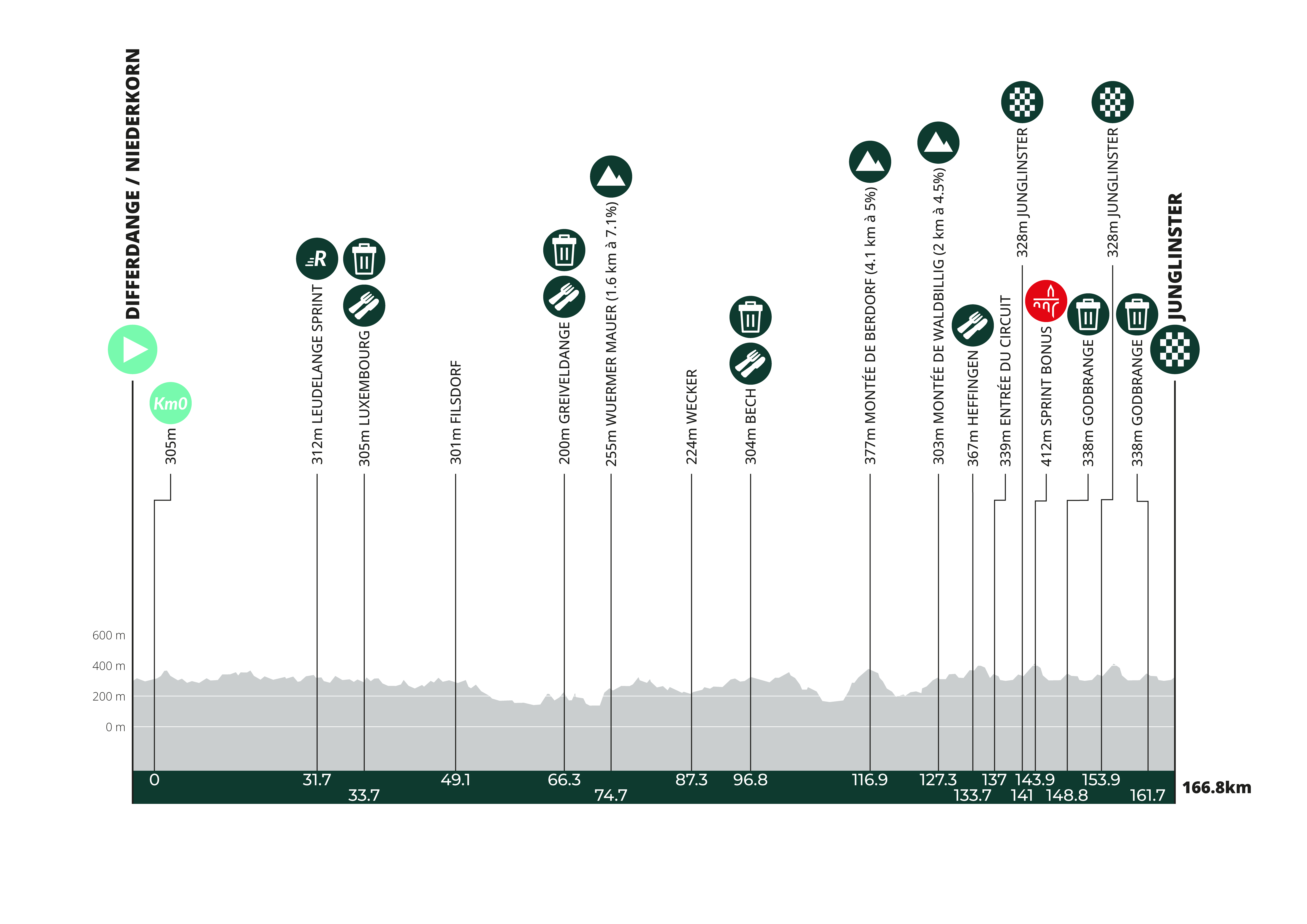
| type | Location | KM to Finish | KM from Start | 40.0 km/h | 42.0 km/h | 44.0 km/h | Altitude | Road / Route | |
|---|---|---|---|---|---|---|---|---|---|
| Neutral start |  | NIEDERKORN | 169.5 | -2.7 | 14:30 | 14:30 | 14:30 | 300.1 | Avenue de la Liberté |
| DIFFERDANGE | 168.7 | -1.9 | 314.9 | N31 | |||||
| km 0 |  | LIDL DIFFERDANGE | 166.8 | 0.0 | 14:35 | 14:35 | 14:35 | 305.4 | CR174 |
| SOLEUVRE | 166.4 | 0.5 | 14:36 | 14:36 | 14:36 | 308.5 | CR174 | ||
| SANEM | 162.9 | 3.9 | 14:41 | 14:41 | 14:40 | 316.3 | CR110 | ||
| NIEDERKORN | 159.8 | 7.1 | 14:45 | 14:45 | 14:44 | 289.3 | CR175 | ||
| DIFFERDANGE | 157.4 | 9.5 | 14:49 | 14:48 | 14:48 | 314.9 | N31 | ||
| OBERKORN | 155.9 | 11.0 | 14:51 | 14:50 | 14:49 | 307 | N31 | ||
| BELVAUX | 153.7 | 13.1 | 14:55 | 14:54 | 14:53 | 349.8 | N31 | ||
| SOLEUVRE | 151.9 | 15.0 | 14:57 | 14:56 | 14:55 | 353.9 | CR178 | ||
| SANEM | 149.3 | 17.5 | 15:01 | 15:00 | 14:58 | 316.3 | CR110 | ||
| UERSCHTERHAFF | 147.3 | 19.5 | 15:04 | 15:02 | 15:01 | 311.7 | CR178 | ||
| LIMPACH | 145.2 | 21.7 | 15:07 | 15:05 | 15:04 | 328.1 | CR178 | ||
| RECKANGE-SUR-MESS | 142.8 | 24.0 | 15:10 | 15:08 | 15:07 | 296 | CR178 | ||
| ROEDGEN | 140.3 | 26.6 | 15:14 | 15:12 | 15:10 | 334.1 | CR178 | ||
| SCHLÉIWENHAFF | 138.2 | 28.7 | 15:17 | 15:15 | 15:13 | 295.8 | CR178 | ||
| LEUDELANGE | 137.1 | 29.7 | 15:18 | 15:16 | 15:14 | 313.6 | CR163 | ||
| RUSH |  | RUSH - Leudelange | 135.1 | 31.7 | 15:21 | 15:19 | 15:17 | 312.2 | CR179 |
| GRASBËSCH | 134.8 | 32.0 | 15:22 | 15:20 | 15:17 | 306.7 | CR179 | ||
| Feed |  | Feed & Waste zone 1 | 133.1 | 33.7 | 15:24 | 15:22 | 15:20 | 305.6 | N4 |
| LUXEMBOURG | 132.6 | 34.2 | 15:25 | 15:22 | 15:20 | 307.7 | N4 | ||
| KOCKELSCHEUER | 130.5 | 36.3 | 15:28 | 15:25 | 15:23 | 306.3 | CR158 | ||
| ROESER | 127.0 | 39.8 | 15:33 | 15:30 | 15:27 | 266.7 | CR158 | ||
| SCHLAMMESTEE | 124.3 | 42.6 | 15:37 | 15:34 | 15:31 | 260.4 | CR132 | ||
| WEILER-LA-TOUR | 123.0 | 43.9 | 15:38 | 15:35 | 15:33 | 270.9 | CR132 | ||
| HASSEL | 121.7 | 45.2 | 15:40 | 15:37 | 15:35 | 281 | CR132 | ||
| FILSDORF | 117.7 | 49.1 | 15:47 | 15:43 | 15:40 | 301.3 | CR162 | ||
| Cattle grid | 2× Cattle grids | 117.3 | 49.5 | 15:47 | 15:44 | 15:41 | 293 | CR162 | |
| BRÉIM | 114.8 | 52.1 | 15:50 | 15:47 | 15:44 | 252.1 | CR162 | ||
| ELLANGE | 113.2 | 53.6 | 15:53 | 15:49 | 15:46 | 240 | CR149 | ||
| ERPELDANGE (BOUS) | 109.9 | 57.0 | 15:57 | 15:53 | 15:49 | 177.5 | CR149 | ||
| BOUS | 107.6 | 59.3 | 16:00 | 15:56 | 15:52 | 158.5 | CR149 | ||
| STADTBREDIMUS | 105.5 | 61.3 | 16:03 | 15:59 | 15:55 | 152 | CR149 | ||
| GREIVELDANGE | 101.6 | 65.3 | 16:09 | 16:05 | 16:01 | 185.5 | CR146 | ||
| Feed | | Feed & Waste Zone 2 | 100.5 | 66.3 | 16:11 | 16:07 | 16:02 | 200.5 | CR146 |
| LENNINGEN | 99.3 | 67.5 | 16:13 | 16:09 | 16:04 | 201.1 | CR146 | ||
| EHNEN | 96.1 | 70.7 | 16:18 | 16:13 | 16:09 | 159.1 | CR134 | ||
| WORMELDANGE | 95.0 | 71.9 | 16:19 | 16:14 | 16:10 | 142.9 | N10 | ||
| KOM |  | Montée "Wuermer Mauer" (KOM1) | 92.1 | 74.7 | 16:26 | 16:20 | 16:15 | 255 | CR122A |
| DREIBORN | 91.9 | 75.0 | 16:26 | 16:20 | 16:16 | 244.5 | CR146 | ||
| FLAXWEILER | 85.2 | 81.7 | 16:36 | 16:31 | 16:25 | 285 | CR122 | ||
| BERG | 82.5 | 84.4 | 16:40 | 16:34 | 16:29 | 248 | CR145 | ||
| WECKER | 79.5 | 87.3 | 16:44 | 16:38 | 16:32 | 224.6 | N14 | ||
| BIWER | 79.0 | 87.8 | 16:45 | 16:38 | 16:33 | 217.2 | N14 | ||
| MARXMILLEN | 77.1 | 89.7 | 16:47 | 16:41 | 16:35 | 238.9 | N14 | ||
| KLOSMILLEN | 76.3 | 90.5 | 16:49 | 16:42 | 16:37 | 249.8 | N14 | ||
| BOUDLERBAACH | 75.8 | 91.0 | 16:49 | 16:43 | 16:37 | 250.7 | N14 | ||
| BOUDLER | 75.3 | 91.5 | 16:50 | 16:44 | 16:38 | 258 | CR136 | ||
| BROUCH (BIWER) | 74.3 | 92.6 | 16:52 | 16:45 | 16:39 | 263.1 | CR136 | ||
| BECH | 71.3 | 95.5 | 16:57 | 16:50 | 16:44 | 305.3 | CR132 | ||
| Feed | | Feed & Waste zone 3 | 70.1 | 96.8 | 16:58 | 16:51 | 16:45 | 303.2 | CR138 |
| HERBORN | 65.8 | 101.1 | 17:05 | 16:57 | 16:51 | 306.3 | CR139 | ||
| OSWEILER | 60.9 | 105.9 | 17:12 | 17:04 | 16:57 | 248.1 | CR139 | ||
| ECHTERNACH | 57.5 | 109.3 | 17:16 | 17:08 | 17:01 | 172.8 | CR139 | ||
| ECHTERNACH | 56.8 | 110.1 | 17:17 | 17:09 | 17:02 | 164.9 | N10 | ||
| BERDORF | 50.4 | 116.5 | 17:30 | 17:21 | 17:14 | 369 | CR364 | ||
| KOM | | Montée de Berdorf (KOM2) | 50.0 | 116.9 | 17:30 | 17:22 | 17:14 | 376.9 | CR364 |
| VUGELSMILLEN | 45.6 | 121.2 | 17:35 | 17:26 | 17:19 | 193.9 | CR364 | ||
| MËLLERDALL | 41.7 | 125.1 | 17:41 | 17:32 | 17:24 | 215.2 | CR121 | ||
| WALDBILLIG | 40.3 | 126.6 | 17:44 | 17:35 | 17:26 | 273.4 | CR356 | ||
| KOM | | Montée de Waldbillig (KOM3) | 39.6 | 127.2 | 17:45 | 17:36 | 17:28 | 302.2 | CR356 |
| CHRISTNACH | 38.3 | 128.5 | 17:47 | 17:38 | 17:30 | 311.3 | CR128 | ||
| Roundabout | Roundabout – via left side (1st exit) | 38.1 | 128.7 | 17:47 | 17:38 | 17:30 | 310.6 | CR128 | |
| HEFFINGEN | 35.1 | 131.7 | 17:52 | 17:43 | 17:34 | 327.5 | CR128 | ||
| Feed | | Feed & Waste zone 4 | 33.2 | 133.7 | 17:55 | 17:46 | 17:37 | 367.2 | CR129 |
| GODBRANGE | 30.2 | 136.6 | 18:00 | 17:50 | 17:41 | 320.4 | CR129 | ||
| Circuit enter | Entrée circuit | 29.9 | 137.0 | 18:00 | 17:50 | 17:42 | 331.2 | CR129 | |
| JUNGLINSTER | 27.7 | 139.1 | 18:03 | 17:53 | 17:44 | 304.1 | CR129 | ||
| Info | JUNGLINSTER 1st finish line crossing | 25.8 | 141.0 | 18:06 | 17:56 | 17:47 | 330.5 | CR121A | |
| GONDERANGE | 25.4 | 141.4 | 18:07 | 17:57 | 17:48 | 341.6 | CR121A | ||
| Sprint bonus |  | Spuerkeess Bonus Sprint | 22.9 | 143.9 | 18:12 | 18:01 | 17:52 | 413.2 | CR122 |
| BOURGLINSTER | 22.1 | 144.8 | 18:13 | 18:02 | 17:53 | 370.6 | CR122 | ||
| ALTLINSTER | 19.5 | 147.3 | 18:16 | 18:05 | 17:56 | 304.9 | CR130 | ||
| Litter zone | Waste zone | 18.0 | 148.8 | 18:18 | 18:07 | 17:58 | 325.7 | CR130 | |
| GODBRANGE | 17.7 | 149.1 | 18:19 | 18:08 | 17:58 | 341.5 | CR130 | ||
| JUNGLINSTER | 14.8 | 152.0 | 18:23 | 18:12 | 18:02 | 304.1 | CR129 | ||
| JUNGLINSTER 2nd finish line crossing | 12.9 | 153.9 | 18:26 | 18:15 | 18:05 | 330.5 | CR121A | ||
| GONDERANGE | 12.5 | 154.3 | 18:26 | 18:15 | 18:05 | 341.6 | CR121A | ||
| BOURGLINSTER | 9.2 | 157.7 | 18:32 | 18:21 | 18:11 | 370.6 | CR122 | ||
| ALTLINSTER | 6.6 | 160.2 | 18:35 | 18:24 | 18:13 | 304.9 | CR130 | ||
| Litter zone | Waste zone | 5.2 | 161.7 | 18:38 | 18:26 | 18:16 | 325.7 | CR130 | |
| GODBRANGE | 4.8 | 162.0 | 18:38 | 18:27 | 18:16 | 341.5 | CR130 | ||
| JUNGLINSTER | 1.9 | 164.9 | 18:42 | 18:31 | 18:20 | 304.1 | CR129 | ||
| End |  | ARRIVÉE JUNGLINSTER | 0.0 | 166.8 | 18:45 | 18:33 | 18:23 | 330.3 | CR121A |
Traffic & Road Closures
Start Area – Differdange/Niederkorn
Finish Area – Junglinster
Along the Route
Along the race route, roads will generally be temporarily closed approximately 10 minutes before the arrival of the first rider.
The road closure is indicated by the “ATTENTION COURSE” opening vehicle with red flags.
The road is reopened after the last riders and race vehicles have passed. The reopening is indicated by the “FIN DE COURSE” broom wagon with green flags.
Between these two vehicles, the road is closed to normal traffic.
Different and longer closures may apply on local circuits and in start and finish areas. Please refer to the specific information above.
Live Traffic Information
Real-time traffic information and disruptions related to the race are also available through Waze, ACL and RTL.
Please follow the instructions of the Police, race marshals and authorised personnel along the route.
For safety reasons, roads along the parcours will be closed to traffic 10–15 minutes before the first rider passes. The closure begins when the red-flag car drives by, and roads will reopen only after the last riders and official vehicles have passed, signaled by the green-flag (broom wagon) car.
Please note:
– Certain roads will be accessible in only one direction for security reasons.
– At the start and finish locations, there will be additional closures as the final circuit will be fully closed to traffic.
You can check the official timing to know when roads will be closed.

Our partner Waze has integrated all road closure information to help you avoid disruptions:

For further updates, please also check the ACL Traffic Info service.
Additional information:
Traffic info Ville de Luxembourg:
 English
 German
 French